
Last lesson, we began learned about the three large countries of North America, Canada, United States, and Mexico, and the many small countries in the Caribbean and Central America regions. Today, we are going to learn about the major landforms of North America!
A landform is
anything that makes a big change in the land, such as mountains, lakes, or deserts. North America has many, many, many small landforms, but we are going to focus on the big ones today!
Let's take a look at the map below, and see how many landforms you can find on it:
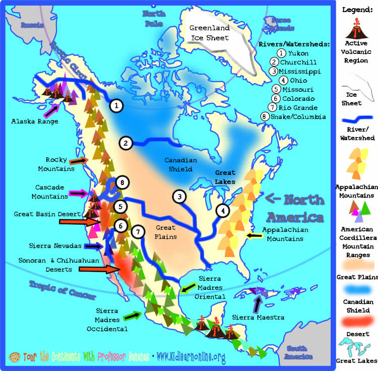 |
Wow! That is a LOT of Landforms! Let's break them down into types, and find out a little about each one!
Major Landforms - Mountains & Deserts
North America has very much been shaped by Plate Tectonics, as most of the earth has. Plate Tectonics is the therory that the crust of the Earth (lithosphere) is made of many plates, kind of like a cracked eggshell. This will glide and move around the Earth, and this is what can cause mountains to be formed , volcanoes, and earthquakes. Let's learn a little about Plate Tectonics first, and this will help us understand some of the landforms of North America (and the rest of the Earth!), and why they are there.
Let's watch a video!
Mountains

View of the Appalachian Mountains |
Appalachian Mountains
The Appalachian Mountains are found in the Eastern part of North America. They are almost 1500 miles long, starting at the very southeast part of the United States, and ending in Canada. They are one of the oldest mountain ranges in the world!
They are not as tall as the mountain ranges in the western part of North America, and the tallest peak is Mt. Mitchell in North Carolina, United States at 6,684 ft tall.
The Appalachian Moutains include many small mountain ranges, such as the Catskills, Blue Ridge, and Cumberland Mountain Ranges. |
The American Cordillera Mountain Ranges run from the top of North America all the way to the tip of Central America, like a backbone for the country! There are many important mountain ranges that make up the Cordllera. A Cordillera is a long, extensive chain of different mountains that usually run parallel to each other. There are other cordilleras in the world, but let's look at the mountain ranges that make up the American Cordillera. Most of these mountains are part of the Pacific "Ring of Fire" and have been created by the volcanic activity of plate tectonics.
Alaska Range
These mountains extend along the Alaskan Penninsula into Canada. They are part of the American Cordillera, a chain of mountain ranges that extends from North America all the way to Antarctica! These mountain ranges are part of the Pacific Ring of Fire, where plate tectonics cause volcanic activity and earthquakes because of the Pacific Plate meeting the continental plates.
The Alaska Range is the third highest mountain range in the world, and has the tallest peak in North America, Mt. McKinley (also called Denali) standing at 20,237 ft. tall! |
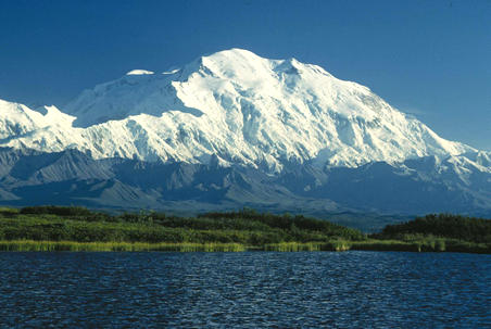
Mt. McKinley |
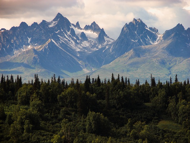
Rocky Mountains in Canada
|
Rocky Mountains
The Rocky Mountains continue as the next mountain range of the American Cordillera. They are very tall, rugged mountains, and extend from far northern Canada through the western part of the United States almost  to Mexico. They extend for almost 3000 miles, and can be as wide as 300 miles in some places. Over 100 different smaller mountain ranges are included in making up the Rocky Mountains. Many places in the Rocky Mountains have been formed and shaped by both volcanic activity and glacial activity. Glacial activity is where a glacier (large mass of ice) has moved over the land.Some of the ice was massive, and could move whole piece of mountain! The picture to the right shows Glacier National Park in the Rocky Mountains where the valley was formed by a glacier moving through kind of like a bulldozer during the Ice Age. to Mexico. They extend for almost 3000 miles, and can be as wide as 300 miles in some places. Over 100 different smaller mountain ranges are included in making up the Rocky Mountains. Many places in the Rocky Mountains have been formed and shaped by both volcanic activity and glacial activity. Glacial activity is where a glacier (large mass of ice) has moved over the land.Some of the ice was massive, and could move whole piece of mountain! The picture to the right shows Glacier National Park in the Rocky Mountains where the valley was formed by a glacier moving through kind of like a bulldozer during the Ice Age.
When the glaciers melted, rocks and soil they picked up as they moved along melted out and stayed in their new spot, sometimes hundreds of miles from where the rock was originally!
More on glaciers
|
Cascade Mountains
The Cascade Mountain Range started forming almost 36 millions of years ago because of the volcanic activity of the pacific plate colliding with the North American plate. They have continued forming over millions of years, and the mountain range today has 13 distinct, large volcanic peaks, including Mt. St. Helens, which erupted in 1980, and the tallest peak in the chain, Mt. Rainer.
Mt. Rainer is 14,411 ft above sea level, and is on a special list of the 16 most potentially threatening volcanoes in the world!
The Cascades stretch from Canada down the Pacific coast of the United States for over 700 miles.
Watch a video of Mt. St. Helen's Eruption!
|

Volcanic Peak in the Cascade Mountains |

Sierra Nevadas
|
Sierra Nevadas
The Sierra Nevada Mountain Range lies in the Southwetern United States and runs for almost 400 miles dividing the states of California and Nevada. It contains the largest alpine lake in North America, Lake Tahoe. An alpine lake is any lake or reservoir that is over 5,000 feet abocve sea level. The Sierra Nevadas are very tall and steep, and were formed over millions of years by uplifis in the crust of the earth from plate tectonics, as well as being carved by glaciers. Even today, earthquakes occur especialy on their eastern side by these uplifts continuing to happen.
|
Sierra Madres Occidental & Oriental
The Sierra Madres Mountain Range extends from the border of the United States through Mexico and Central America. Sierra is Spanish for Mountain, and Madres is Spanish for mother - they are the Mother Mountains. The range is divided into two mountain ranges, the Sierra Madres Occidental which are on the western part of Mexico, and Sierra Madres Oriental, which is on the eastern part of Mexico.
These mountains have volcanic and uplift histories over millions of years. The southern region of the Sierra Madres has many active volcanoes. These are in an area called the Trans-Mexican Volcanic Belt. Many of the large volcanoes have erupted within the last 500 years! Pico de Orizaba is the largest volcanic peak in the Sierra Madres rising 18,406 feet above sea level. It last erupted in 1687.
|

Pico de Orizaba
|
Sierra Maestra
The Sierra Maestra Mountain Range is one of the largest Mountain Ranges in the Caribbean. It is the highest on the island of Cuba and is very rich in minerals such as copper and iron. It rises sharply upwards from the island. It's highest peak is Pico Turquino at 6,476 ft above sea level.. |

Mountains in Cuba
|
Deserts
Great Basin
The Great Basin Desert is located in the Southwestern part of the United States.
In this area, the crust of the Earth has been stretched so much by plate tectonics, that it is the thinnest part of the Earth's crust anywhere in the world!
The lowest point in North America is also located here. It is
called Badwater Basin in Death Valley. It is 282 ft below sea level!
This desert is part of an area called the Basin and Range. Basin and Range simply means you have a landscape with large mountains, followed by very low lying "basin" areas, then another large mountain range ... kind of an up-and-down rollercoaster!
Because of this, there are many different animals and plants in the high mountains springing out of the desert that are very different from the animals and plants living in the low basin areas between mountain ranges.
The Great Basin Desert, Death Valley, Badwater Basin, United States ---->
|

|
 |
Sonoran Desert
The Sonoran Desert is located in the Southwestern part of the United States and Northern Mexico. It is very arid, which means it is very hot and dry. Many cactus live in the Sonoran Desert. The really tall cactus in the picture are called Saguro (Saw-wore-oh) Cactus, and can grow 70 feet tall and live over 150 years! They do not grow anywhere else in the world except the Sonoran Desert. The Sonoran Desert is the hottest desert in Mexico. It also has many Basin and Range areas like the Great Basin Desert. Many animals and plants that live in the mountains are different from the animals in the low lying desert areas between them.
<------------------- Sonoran Desert featuring a hillside of Saguro Cacti |
Chihuahuan Desert
The Chihuahuan Desert is also located in the Southwestern part of the United States and Northern Mexico. It is not quite as hot as the Sonoran Desert, and is located roghly between the Sierra Madre Occidental and Sierra Madre Oriental Mountain Ranges. Also a Basin and Range area, the mountain ranges in the Chihuahuan Desert are often called "Sky Islands" . They are often strikingly different from the semi-arid desert basins, as they can be much wetter and cooler in temperature. Also, they are so isolated, they often have species of animals and plants living on them that are found no where else in the world since they have adapted to their sky island!
Chihuahuan Desert, Texas, United States ------------------> |
 |
So, now you have learned about the many mountain ranges of North America, including the Rocky Mountains, the Sierra Madres (both of them!) and many of the other large mountain ranges. We also learned about the three deserts, the Great Basin (don't forget Badwater Basin is the lowest point in North America!), the Sonoran, and the Chihuahuan Deserts.
Next lesson, we will learn about the major lakes, rivers, and other landforms!
What We Learned in This Lesson:
* North America has many major mountain ranges.
* The oldest mountain range in North America are the Appalchian Mountains.
* The American Cordillera is like a long backbone of different mountain ranges from the top of North America to the bottom of North America..
* Many of the American Cordillera mountain ranges are volcanic. Some have helped been formed by glaciers.
* The eight major mountains are: Appalachians, Alaska Range, Rocky
Mountains, Cascades, Sierra Nevadas, Sierra Madres Occidental, Sierra Madres Oriental, and the Sierra Maestras.
* The
three major deserts are the Great Basin, Sonoran, and Chihuahuan Deserts.
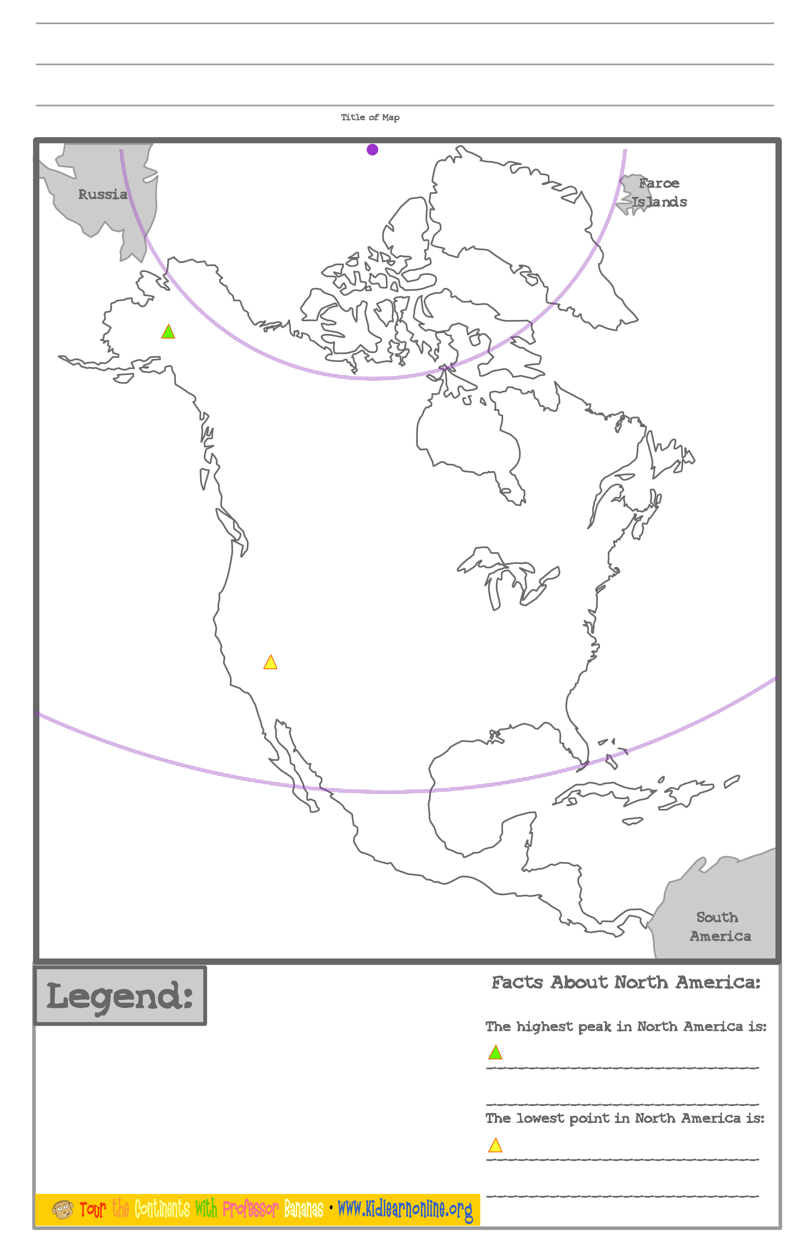
* The highest peak in North America is Mount McKinley (also called Denali) in the Alaska Range.
* The lowest point in North America is Badwater Basin in the
Great Basin Desert.
Downloads For Your Workbook:
Map- Download the map, title it "Mountains & Deserts of North America" and label the major mountains and deserts around North America you just learned about.
You can use the map legend to help label the mountains and desert by using different colors and putting the map key in the legend.
Info Sheet - Answer the questions on the info sheet for your book, and put both papers into your Tour the Continents notebook.
|
Banana Peels
Central America
has over 70 volcanoes!
These volcanoes help make the farmland of Central America very fertile, and many crops, especially bananas, are grown here.
|
|
